GIS in Action: 10 Ways Digital Mapping is Improving the World Around Us
Geographic Information Systems (GIS) technology has long been associated with local government operations—zoning, infrastructure planning, and utility management. However, GIS is increasingly shaping quality of life in ways that go far beyond municipal planning. From aiding disaster response to improving accessibility, here are ten recent stories that highlight how GIS is making the world safer, more efficient, and more inclusive.

1. Wildfire Response and Management
GIS is playing a crucial role in wildfire response, helping emergency teams track fire progression, manage evacuations, and allocate resources efficiently. GPS World highlights how GIS tools provide real-time situational awareness, allowing responders to overlay fire behavior models with weather conditions to predict fire spread and mitigate damage.

2. Mapping Marriage Trends Across the U.S.
Esri’s ArcGIS team explored the geography of marriage across the United States, uncovering regional patterns in marital status. Their interactive map provides insights into how social and economic factors influence marriage rates, illustrating how GIS can help analyze demographic trends that shape communities.

3. Preserving African American Burial Sites in Charleston
In Charleston, South Carolina, GIS is being used to document and preserve African American burial sites that were at risk of being lost to urban development. According to ABC News 4, the digital mapping initiative helps identify grave sites, provide historical context, and ensure their long-term protection, reinforcing how GIS can be a powerful tool for cultural preservation.

4. Promoting Wellness Through Digital Greenspace Mapping
North Carolina State University researchers have developed a digital greenspace map to help communities access outdoor areas for recreation and mental well-being. By pinpointing parks, trails, and other green spaces, this GIS-driven initiative supports urban planning efforts that prioritize public health.

5. Mapping Aircraft Maintenance for Improved Safety
In aviation, GIS is being used to track aircraft maintenance and optimize repair schedules. Aviation Business News reports that digital mapping tools are enhancing the efficiency of maintenance, repair, and overhaul (MRO) operations, reducing downtime and improving flight safety.

6. 3D Rainforest Digital Twins for Reforestation in Costa Rica
Conservationists in Costa Rica are using 3D digital twin technology to map rainforests and support reforestation projects. These detailed digital replicas help monitor biodiversity, assess tree growth, and plan restoration efforts with unprecedented accuracy.
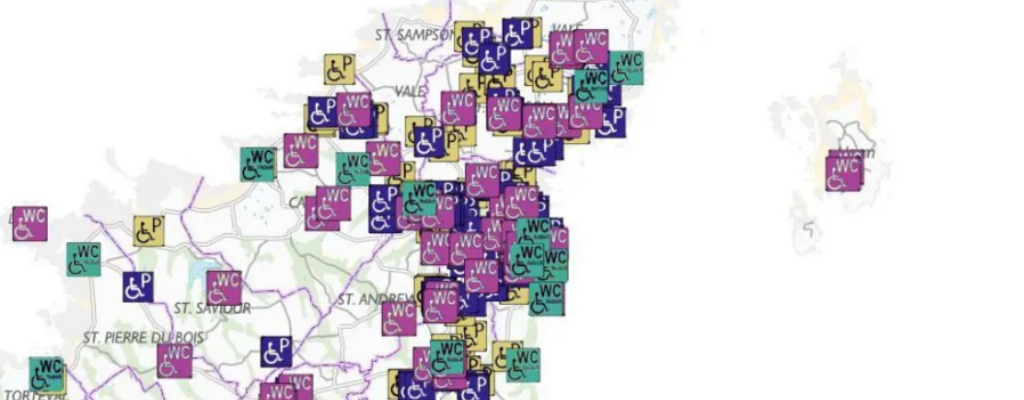
7. Improving Accessibility with a Digital Map for Disabled Toilets
In the UK, a new GIS-powered digital map is helping individuals with disabilities locate accessible toilets. As reported by the BBC, this initiative enhances mobility and independence by providing essential location data in an easy-to-use format.

8. Enhancing Search and Rescue Operations in Alberta
A new digital mapping tool in Alberta is revolutionizing search and rescue operations by providing real-time tracking of rescue teams and missing persons. According to Lakeland Today, GIS enhances coordination and response times, improving survival chances in remote and hazardous environments.

9. Mapping Accessibility to Public Art in Toronto
A new GIS-powered digital map in Toronto allows residents and tourists to explore public art installations while promoting accessibility. Users can filter artwork based on location, type, and accessibility features, making cultural engagement more inclusive.
10. NYC Parks Launches a Digital Map for Visitors
New York City’s parks department recently unveiled an interactive digital map that helps visitors navigate the city’s extensive green spaces. The tool provides information on park facilities, accessibility features, and historical landmarks, enhancing the visitor experience.
The Expanding Role of GIS in Everyday Life
These diverse applications illustrate how GIS technology extends far beyond local government administration. From preserving cultural heritage to improving emergency response and environmental sustainability, digital mapping is reshaping how we interact with the world. As GIS continues to evolve, its role in safety, efficiency, and accuracy will only grow, making it an indispensable tool for improving quality of life.