When Seconds Count: How Indoor GIS Mapping Is Changing School Safety
There is a question that school administrators, sheriffs, and first responders carry into every school year: If something happens today, are we ready?
The answer, for too many districts, is incomplete. They have emergency plans — printed, filed, sometimes laminated. But when a real crisis unfolds, plans sitting in a binder are not the same as situational awareness in the moment. That gap is exactly where GIS-based indoor mapping enters the picture.
The Reality of School Violence in the United States
The numbers are difficult to sit with, but they matter. Since Education Week began tracking school shootings in 2018, the organization has counted 221 incidents through the end of 2024, with at least one shooting occurring every month of the year. EdWeek The four years following the pandemic represented the worst stretch of school gun violence since at least 2008. Get Safe and Sound
Response time is at the center of why this is so devastating. Police response takes a minimum of eight minutes, while violence can unfold in a matter of seconds, and approximately two-thirds of active shooter incidents end before law enforcement even arrives. Volt A U.S. Department of Justice review found that a faster police response to the 2022 mass shooting in Uvalde, Texas, could have saved lives. EdWeek
That eight-minute window is a spatial problem as much as a logistical one. Officers arriving at an unfamiliar building, unsure where hallways connect, where closets are, where the water shutoff is located, lose precious seconds navigating space they’ve never seen. Indoor mapping directly addresses that.
What Indoor GIS Mapping Actually Does
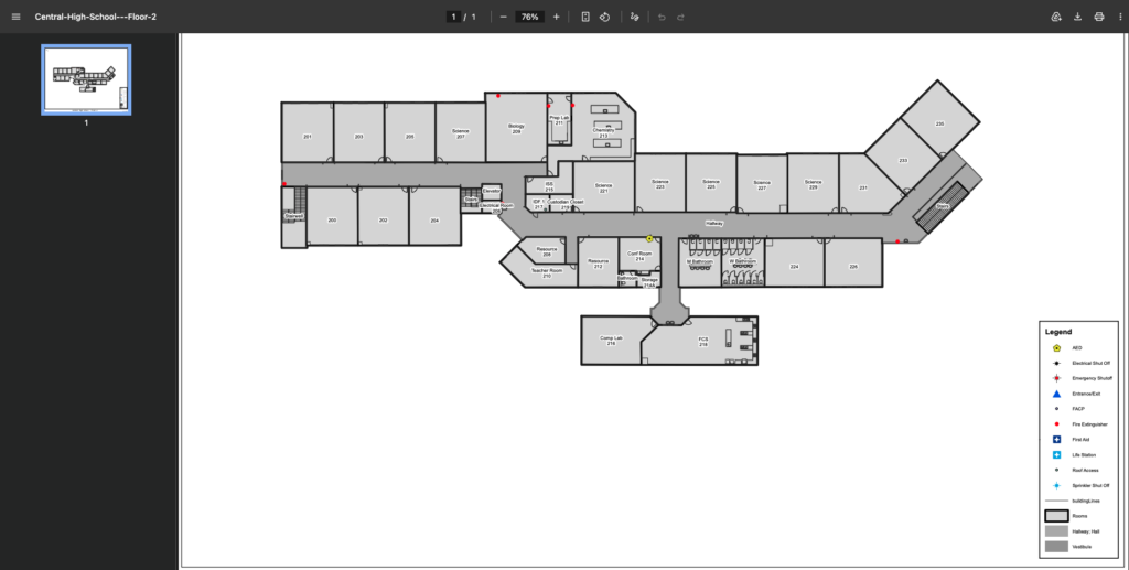
Most first responders arriving at a school emergency have never been inside that building. Indoor GIS mapping changes that. Think of it as giving them a virtual walk-through before they ever arrive on scene. These maps provide an immediate, up-to-date overview of the building layout, including site and roof access points, building entrances and exits, and the locations of lifesaving equipment such as first aid kits, fire extinguishers, and AEDs.
Beyond equipment locations, these maps identify rooms by number and use, including classrooms, libraries, gyms, and storage closets, and include all internal and external doorway and window locations. That standardization matters more than it sounds. Teacher names change, room assignments shift, and a caller in a crisis is unlikely to know their room number off the top of their head. Building a map around permanent, numbered spaces rather than the people temporarily occupying them means responders are always working from information that holds up.
The difference shows up clearly in how a response unfolds. When a dispatcher can pinpoint exactly which corridor a caller is in, and a responding officer can pull up the building layout on a mobile device before stepping out of the vehicle, the first minutes of an emergency look very different. Responders stop searching and start acting. That shift, from orientation to response, is where lives are saved.
From Trails to Schools: How InteractiveGIS and King-Moore Are Bringing This to Virginia
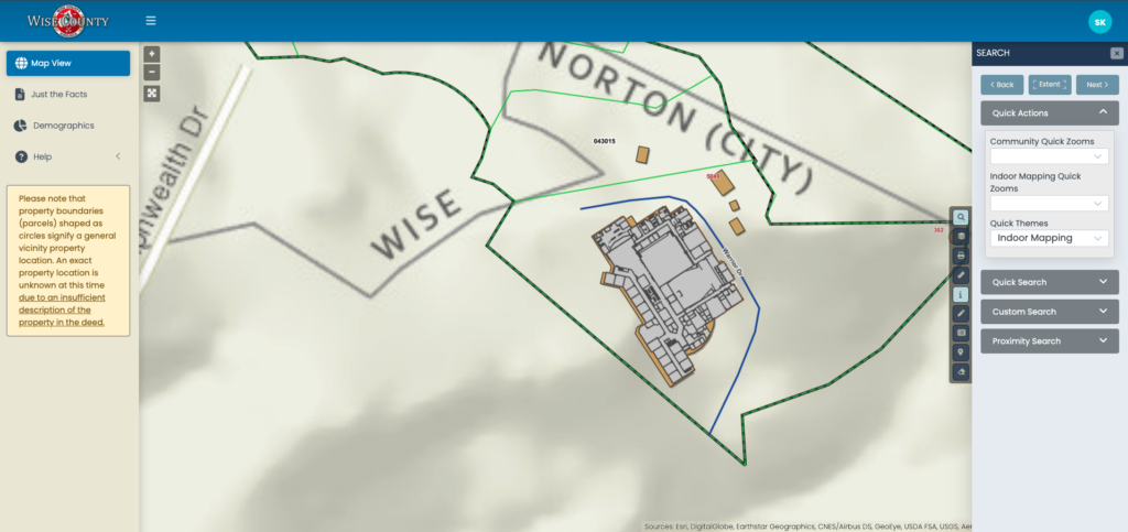
InteractiveGIS clients already understand what it means to have spatial data working for them, and Wise County, Virginia is a strong example of that. Wise County has long used iGIS® for county-wide mapping, including a previous integration with EagleView that gave county employees direct access to high-resolution aerial imagery for emergency services and property assessment without ever leaving the GIS platform.
That same commitment to preparedness now extends indoors. InteractiveGIS partnered with King-Moore, Inc., the same firm that brought 360-degree trail imagery to Washington County’s interactive maps, to capture 3D visual imaging of Wise County’s schools and convert it into intelligent indoor mapping integrated directly into the county’s GIS.
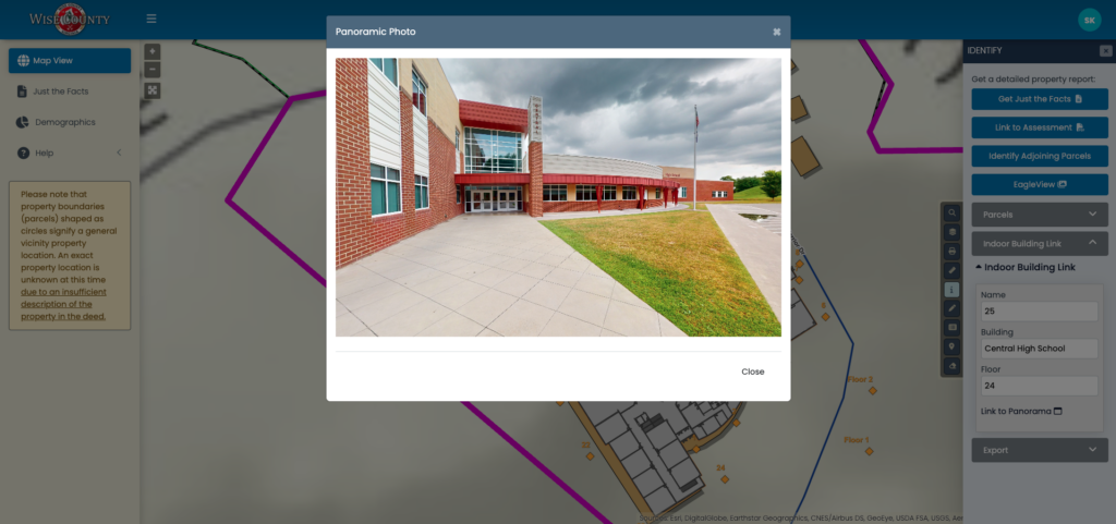
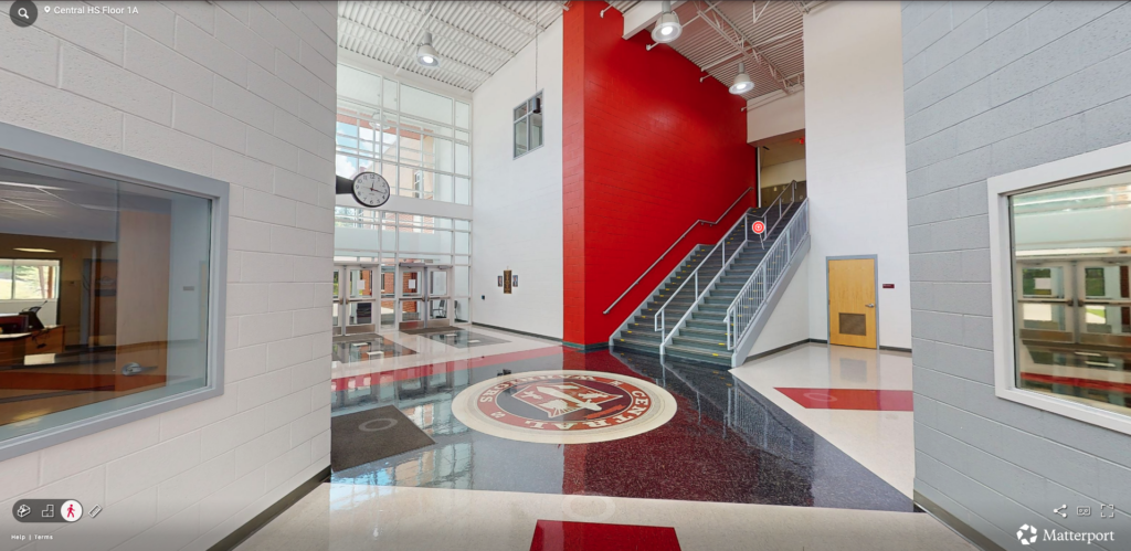
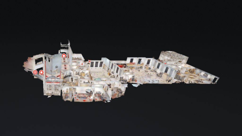
The process starts with 3D imaging cameras that capture a complete interior view of each school building. That imagery gives authorized users a virtual walk-through of the space, with labeled rooms, searchable locations, and actual dimensions that can be measured directly from the virtual view. Supporting documents are embedded directly into the imagery as well, so a responder virtually moving through a building can pull up an electrical box diagram, an evacuation pre-plan, or safety information for a specific room without ever leaving the map. The 3D imaging is then converted into a detailed floor plan that is georeferenced and layered into the GIS as an overlay.
When a 911 Call Comes In
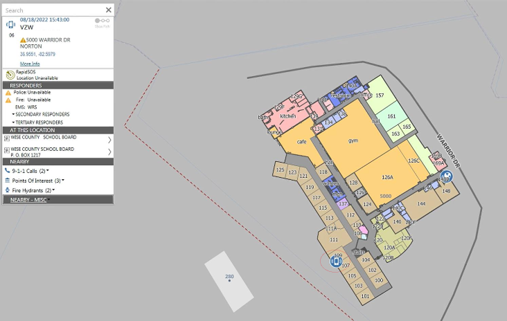
From there, the data becomes genuinely actionable. A dispatcher can type a building name and room number into the search field and immediately locate that room on the map, with it highlighted and responder information populated alongside it. For multi-story buildings, the system allows dispatchers to toggle between floors, so they can tell responding units exactly which level to head to. If a 911 call comes in from a landline or mobile phone inside the building, the system plots that call’s location directly on the indoor floor plan, showing dispatchers precisely which room it originated from.
That same mapping is visible to school resource officers in the field, not just to dispatchers. Everyone working the incident is looking at the same picture of the building in real time.
The data layers can also include entrances, exits, AED locations, hazardous materials storage, and other details that matter when seconds count. It’s the kind of information that has always existed somewhere in a filing cabinet or a facilities office. What King-Moore and InteractiveGIS have done is put it where it can actually be used.
This Is Preparedness, Not Reaction
Indoor mapping is a meaningful shift in philosophy, from reacting to emergencies to preparing for them with specificity. Many states are now providing funding to help school districts transition from static hard-copy maps and floor plans to dynamic, interactive GIS maps, and publishing this data to state 9-1-1 data hubs puts critical information directly in the hands of dispatchers and first responders.
For school systems that have never considered GIS as a safety tool, the starting point is simpler than you might expect. The data you need, floor plans, building layouts, utility access points, likely already exists in some form. The work is organizing it, georeferencing it, and putting it somewhere that responders can actually access under pressure.
If you’d like to see how iGIS® can support your district’s safety planning, we’d welcome the conversation. We offer a 90-day free demo using your own data. Reach us at info@interactivegis.com or 540.239.0950.