Predicting Crime, Protecting Lives: The Power of GIS
Imagine a world where law enforcement is steps ahead—where patrols are optimized, resources strategically deployed, and crime hotspots detected before incidents even happen. This isn’t science fiction—it’s the reality of predictive policing powered by GIS. At InteractiveGIS, we believe in equipping public safety agencies with the tools they need to make our communities safer, smarter, and more resilient.
As highlighted in the Department of Homeland Security’s publication “Geographic Information Systems and Predictive Policing Application Note“, predictive policing can be a valuable tool for law enforcement agencies. Here’s how our iGIS© software can revolutionize public safety efforts and enhance your agency’s crime prevention strategies:


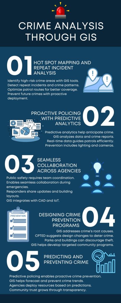
1. Hot Spot Mapping and Repeat Incident Analysis
Crime is rarely random. GIS tools, like those integrated into predictive policing systems, help reveal patterns by identifying high-risk areas known as hot spots. A hot spot is a location with higher-than-average crime, typically clustered around places where opportunities for illegal activity arise, such as abandoned buildings or poorly lit streets
Moreover, GIS-powered repeat analysis reveals trends where crimes reoccur at the same location (like multiple break-ins at the same store) or within close proximity (like a rash of similar home burglaries in the same neighborhood). Understanding these patterns helps law enforcement optimize patrol routes and strategically deploy resources to prevent future crimes before they happen
2. Proactive Policing with Predictive Analytics
With predictive analytics, law enforcement agencies can do more than just react to crime—they can anticipate it. GIS technology analyzes a wealth of data, including historical crime reports, social media activity, and even environmental factors like unemployment or poverty levels. This allows agencies to predict where and when crimes are likely to occur, helping them deploy resources more effectively. GIS modules demonstrate how real-time data can guide patrols to areas where crimes are most likely to occur, deterring criminal activity before it begins
Predictive analytics also support situational crime prevention—for instance, improving street lighting or placing surveillance cameras in high-risk areas, directly reducing the likelihood of crime by influencing behavior.
3. Seamless Collaboration Across Agencies
Public safety is a team effort, requiring coordination among police, fire, and EMS departments. GIS platforms make this collaboration seamless. During emergencies, responders can share real-time updates and access building layouts on mobile devices, ensuring faster, more efficient decision-making. Some systems even use alerts to notify officers when new crime patterns emerge or when they need to shift patrols to a developing hot spot
GIS-based tools also integrate with other systems like computer-aided dispatch (CAD), records management systems, and IoT networks, providing a common operating picture for everyone involved in an emergency response.
4. Designing Crime Prevention Programs Using GIS Insights
GIS platforms don’t just respond to crime—they help address its root causes. Crime Prevention Through Environmental Design (CPTED), for example, uses GIS data to map vulnerable areas and suggest design changes that can deter crime. This could involve redesigning parks to increase pedestrian traffic or building apartments with windows overlooking parking lots to discourage vehicle theft
Additionally, GIS insights enable agencies to develop community programs targeting specific neighborhoods. Identifying social factors like poverty, unemployment, and lack of educational resources helps law enforcement collaborate with community leaders to implement effective interventions—like after-school programs for at-risk youth, reducing the potential for criminal behavior from the outset.
5. Real-World Impact: Predicting and Preventing Crime
Predictive policing, powered by GIS, offers a proactive approach to crime prevention that combines data analysis with community-focused strategies. Rather than waiting for a crime to happen, law enforcement can forecast crime trends, deploy resources accordingly, and even design environments that discourage criminal activity. With this approach, agencies can foster trust, transparency, and safety in their communities by keeping residents informed and engaged.
Ready to Take Public Safety to New Heights?
At InteractiveGIS, we understand the challenges public safety agencies face in today’s world. Our iGIS© software is built to empower law enforcement with the latest in GIS technology—providing predictive analytics, seamless collaboration tools, and real-time crime mapping capabilities. Contact us today for a free consultation to see how we can help you make your community safer and more resilient.
Remember, a safer community starts with clearer insights. Let’s build it together.


