Public works directors across the East Coast spent Monday morning doing the same mental math they do after every major storm. Which neighborhoods still need attention, which crews hit their routes on time, and which decisions made during the scramble actually held up under pressure.
With another system rolling in across the southeast again this weekend, the luxury of post-storm reflection gets cut short, and teams shift back into planning mode with one practical question driving everything — how do we get better at this before the next one hits? This is where GIS does its best work, not as a flashy tool, but as the connector that helps teams see conditions clearly and act with confidence.
Preparation Starts Before the Weather Turns
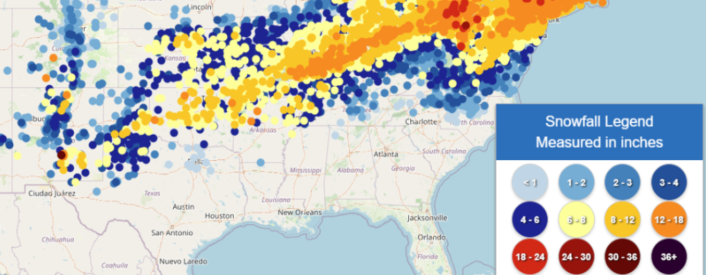
Winter storm management begins well before the first flakes fall. GIS allows localities to layer weather forecasts from agencies like the National Weather Service with road networks, elevation data, historical trouble spots, and critical facilities. When these layers come together, patterns emerge quickly.
Low-lying roads that flood and refreeze, shaded corridors that stay icy longer, or neighborhoods that consistently lose access during snow events stop being anecdotal concerns and become visible risks you can plan around. This early clarity helps public works and emergency managers move from reactive scrambling to targeted preparation, staging crews and equipment where they are most likely to be needed instead of guessing based on last year’s notes.
Routes That Adjust When Reality Shifts
Once a storm is underway, conditions rarely unfold evenly across a jurisdiction. GIS supports dynamic routing for snowplows, salt trucks, and emergency vehicles by factoring in priority roads, school routes, hospital access, and real-time updates from field crews.
Instead of relying solely on fixed routes or last-minute calls, staff can adjust assignments based on what is actually happening on the ground. When arterial roads clear faster than expected while a secondary connector becomes impassable due to downed trees, field supervisors can reroute equipment and crews without losing sight of which school zones still need attention or which hospital access roads remain untreated. Teams pivot quickly without losing the bigger picture of system-wide coverage.
Field Data That Updates in Real Time
The difference between outdated information and actionable intelligence often comes down to how quickly field personnel can report what they are seeing. Custom dashboards and mobile data collection modules built into platforms like iGIS® allow crews to log road conditions, document hazards, report equipment issues, and update treatment status directly from their trucks without waiting to get back to the office or relay information through dispatchers.
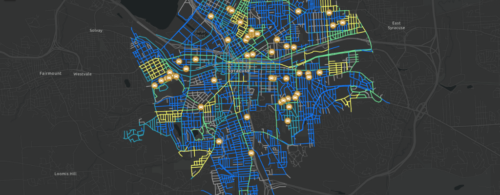
This real-time field input feeds directly into the operational map that supervisors and emergency managers are watching, which means decisions get made with current information rather than assumptions from an hour ago. When a plow operator marks a route as completed or flags a downed power line blocking access, that update is visible immediately to everyone who needs it. Check out Syracuse, New York’s live interactive snow plow map for a great example.
The result is better coordination, fewer redundant trips, faster response to emerging problems, and a clearer picture of storm progress across the entire jurisdiction. Custom modules can be tailored to match your agency’s specific workflows, whether that means tracking salt usage, documenting citizen requests, or logging equipment deployment, so field teams are not wrestling with generic forms that do not fit how they actually work.
When Every Department Needs the Same Map
Winter storms stress-test coordination in ways few other events do. Public works, police, fire, utilities, and communications teams all operate under pressure, often with overlapping responsibilities and competing priorities.
GIS acts as a shared operational view, reducing confusion about road closures, downed power lines, warming centers, and response priorities. When everyone is referencing the same map, decisions become easier to justify internally and externally, and fewer resources get wasted on duplicated effort or contradictory information.
This shared view becomes critical when storms stretch across multiple days and staff fatigue starts to fragment decision-making.
Public Maps That Answer Real Questions
Residents do not need to see every internal dataset, but they do need clear, trustworthy information delivered in a format that makes sense at a glance.
GIS-powered public maps and dashboards help localities communicate plow progress, road conditions, facility closures, and safety guidance without relying on long text updates that are hard to interpret under stress. A simple map answers the questions people care about most — can I get out of my neighborhood, is my route passable, and where should I avoid traveling right now? This kind of clarity builds trust during moments when patience is already thin and misinformation spreads quickly.
Learning from the Storm After It Passes
Once roads reopen and crews stand down, GIS continues to add value in ways that shape future performance. By analyzing response data spatially, localities can see where delays occurred, which routes required repeated treatment, and how resource allocation matched actual need.
These insights feed directly into future planning, helping agencies refine priority routes, adjust staffing models, and make defensible budget requests tied to real-world conditions rather than assumptions or anecdotes. Over time, this feedback loop turns each storm into a data point that improves the next response rather than just another exhausting event that fades from memory.

Moving Forward
Winter storms remain unpredictable, but the operational decisions surrounding them do not have to be. GIS provides local governments a way to see risk earlier, respond more precisely, and defend their choices with clarity, turning complex weather events into manageable operational challenges rather than crises driven by incomplete information.
If your team is still relying on fixed routes and reactive adjustments, the next storm is a good reason to reconsider that approach. InteractiveGIS works with public works and emergency management teams to build web-based mapping solutions that support better decisions before, during, and after winter weather events. Explore how custom dashboards and real-time field data collection can improve your storm response at interactivegis.com.