
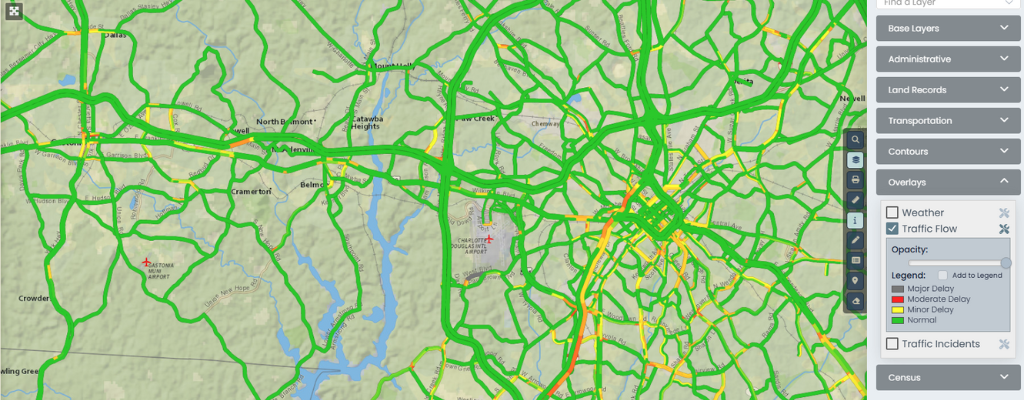
When we think of live traffic data, our minds often jump to apps like Google Maps or Waze. But what if your local GIS could tap into that same power; not just for navigation, but to improve how your city, county, or state operates?
For local governments, integrating a live traffic layer into your GIS platform isn’t just a flashy add-on. It can improve daily operations, reduce response times, and even help save lives.
Here’s how that works—and why it’s worth your attention.
1. Improved Emergency Response

When fire, police, or EMS crews need to move quickly, up-to-the-minute traffic information is critical. By integrating a real-time traffic feed into GIS dashboards used by dispatchers and first responders, departments can:
- Identify the fastest available routes dynamically
- Reroute in real time if an accident or backup occurs
- Avoid construction zones or closures before they cause delays
This kind of system has been adopted in various forms across the country. For example, New York State shares real-time traffic data with emergency services via a connected traffic operations center.
2. Smarter Public Works & Maintenance

Public works departments can plan road repairs, utility work, or snow removal more efficiently when they know traffic conditions in real time. With this data overlaid in a GIS:
- Crews can avoid high-traffic hours or reroute vehicles to minimize congestion
- Traffic impact of road closures can be modeled before permits are issued
- Plow routes and waste pickup can dynamically adjust to traffic volume or detours
North Carolina DOT uses similar integrations to plan maintenance activities around real-time traffic trends, improving safety and efficiency.
3. More Effective Planning & Policy

Long-term transportation planning isn’t just about static maps. Overlaying historical and live traffic data in GIS can:
- Highlight choke points or high-accident corridors
- Justify new traffic calming measures or signal adjustments
- Predict how new development will affect flow on nearby roads
This is a growing priority in smart city initiatives. For example, San Diego’s smart mobility program uses live traffic feeds to inform infrastructure investment and reduce emissions.
4. Public-Facing Benefits for Citizens
Local governments can also use live traffic data in GIS to serve the public directly. Imagine a web-based GIS viewer that:
- Lets residents plan school drop-offs based on current traffic
- Helps commuters find alternate routes before getting stuck
- Shows road closures and detours during emergencies or events
When this data is integrated into a public-facing map portal, it builds transparency and trust. Utah’s UDOT Traffic system is a great example—open access to real-time GIS data helps residents make better travel decisions.
5. Cost Savings Through Optimization
Better routing = less fuel, less wear and tear, and fewer overtime hours. GIS systems with real-time traffic overlays let departments:
- Analyze travel time per route and shift schedules accordingly
- Optimize fleet usage and reduce idle time
- Improve coordination between agencies during large-scale events or weather events
The U.S. DOT has studied these impacts, and even small improvements in route efficiency can translate to significant cost savings across a fleet.
A Final Note
Real-time traffic in GIS isn’t a luxury feature—it’s fast becoming essential infrastructure. Whether you’re planning a snowplow route or a public safety response, having that data live in your local map saves time, money, and often lives.
At InteractiveGIS, we specialize in helping counties and municipalities integrate dynamic data-like traffic feeds into custom-built, web-based GIS tools. If you’d like to see how it could work using your own data, reach out for a free demo.


