
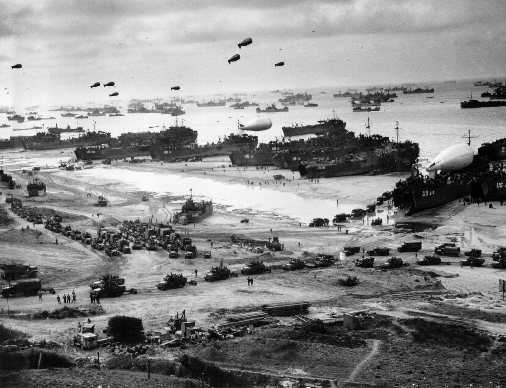
When we think of D-Day, images of brave soldiers storming the beaches of Normandy come to mind. But behind the scenes, a different kind of hero played a crucial role—American cartographers and geospatial experts whose work made the landings at Omaha and Utah Beaches possible. Their story is a powerful reminder of how mapping and science can change the course of history.
The Challenge: Mapping the Unknown
In early 1944, Allied commanders faced a daunting challenge: plan the largest amphibious invasion in history against heavily fortified German positions. Success hinged on knowing every sandbar, bluff, and hidden obstacle along the French coast. The Army Map Service, based in Washington, D.C., became the nerve center for this effort, producing thousands of detailed maps that would guide troops, ships, and aircraft on June 6, 1944.
But these weren’t ordinary maps. They were mosaics of intelligence—blending aerial photographs, submarine surveys, and reports from French resistance fighters. Each layer of information was painstakingly gathered, sometimes at great personal risk. Allied pilots flew dangerous reconnaissance missions over Normandy, dodging anti-aircraft fire to capture up-to-date, three-dimensional images of the beaches and defenses.
The Science of Sand: An Unexpected Hero
One of the most fascinating and lesser-known aspects of the D-Day mapping effort was the analysis of beach sand. American intelligence officers collected sand samples from Omaha Beach, sometimes with the help of covert teams and local resistance. These samples were shipped back to the U.S., where experts analyzed them for grain size, moisture content, and even soil composition.
Why go to such lengths? The answer is simple: tanks and trucks needed to cross the beach without getting stuck. If the sand was too soft or muddy, vehicles could bog down, putting lives and the entire mission at risk. The resulting maps included not just topography and enemy positions, but also detailed notes on the sand’s ability to support heavy equipment—a level of detail that proved life-saving on D-Day.
The maps used by the American military to plan the Omaha Beach landings offer a detailed picture of the Normandy coast with practical notes”
— Boston Rare Maps
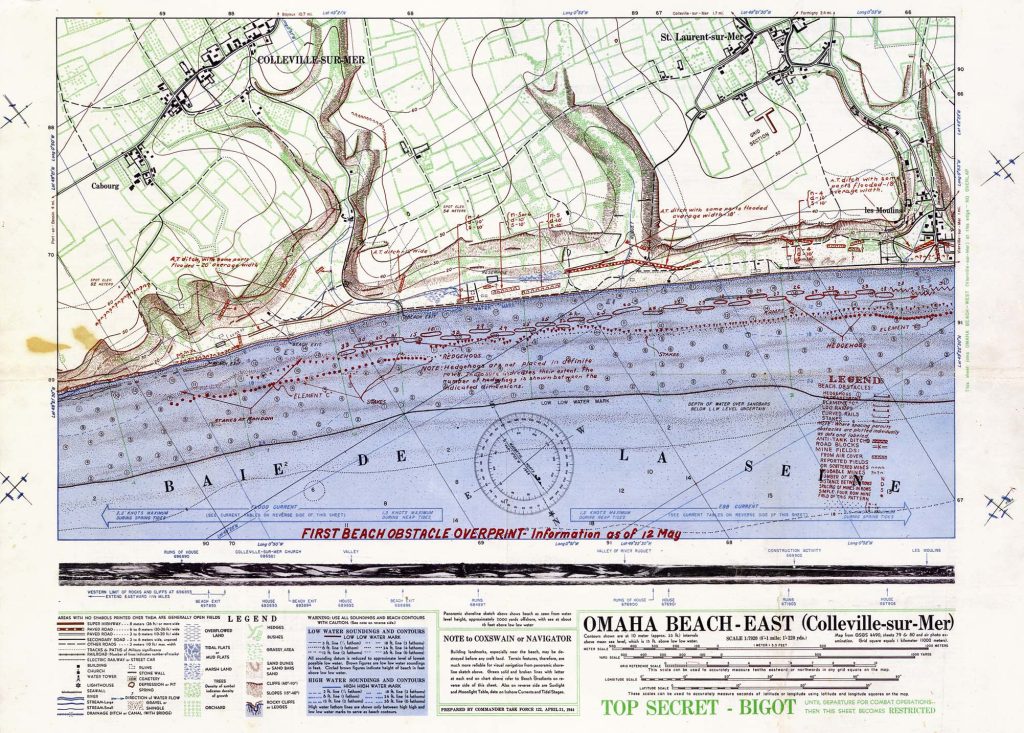
The BIGOT Maps: Top Secret Tools of Victory
Among the most vital resources were the so-called “BIGOT” maps—bearing the highest security classification. These maps combined everything the Allies knew about the beaches: water depths, tides, German defenses, and terrain profiles. They were so sensitive that only a select group of commanders and planners ever saw them before the invasion.
The Neptune Monograph, for example, was a briefing book issued to senior American officers. It included the famous two-sheet maps of Omaha and Utah Beaches, summarizing the latest intelligence and updated with new information right up until the invasion.
The Lasting Legacy: Science and Sacrifice
Today, the sands of Omaha Beach still bear the scars of June 6, 1944. Geologists have found microscopic beads of iron and glass—remnants of bombs and vehicles that exploded during the battle—mixed in with the natural grains. These tiny particles are a physical reminder of the ferocity of D-Day and the scientific effort that helped make victory possible.
The story of D-Day’s maps is more than a tale of paper and ink. It’s a testament to American ingenuity, teamwork, and the belief that knowledge can save lives. As we honor those who served on Memorial Day, let’s also remember the quiet heroes—the cartographers, geologists, and intelligence officers—who mapped the way to freedom.
Sources:
- Library of Congress: D-Day’s Top Secret Map
- Army Map Service – Wikipedia
- National Air and Space Museum: D-Day Aerial Photography
- ConocoPhillips: D-Day 80 Years Later
- Boston Rare Maps: Secret D-Day Maps
- Science History Institute: The Science of D-Day
- Coastal Care: D-Day’s Legacy Sands
- Rare Maps: Neptune Monograph

