The Power of Parcel-Level Mapping in Broadband Expansion
As federal and state agencies invest billions into bridging the digital divide, local government entities are facing a pivotal question: Do we have the right map to guide broadband expansion?
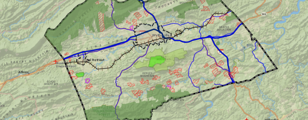
While census blocks and zip codes were once the default for planning internet infrastructure, today’s broadband efforts require precision. That’s where parcel-level GIS comes in, giving local governments the ability to visualize need, document eligibility, and manage projects down to the property line.
Why Expanding Broadband Really Matters

Before diving into the mapping, it’s worth pausing to ask why broadband matters so much—especially in rural areas.
- Remote Learning: During the pandemic, over 15 million students lacked reliable internet access at home, a problem known as the “homework gap”. While schools have returned to classrooms, digital learning isn’t going away. Students in rural or underserved areas still risk falling behind without a stable connection.
- Telehealth & Aging in Place: For older adults, broadband enables telemedicine, remote health monitoring, and virtual check-ins with caregivers. This is especially critical as rural hospitals close and populations age. A study by AARP found that 77% of adults 50+ want to age in place but they need internet-connected devices to do so.
- Agriculture & Small Business: High-speed internet supports precision agriculture, supply chain coordination, and online sales for rural entrepreneurs. The USDA has emphasized broadband as key to modern farming and economic development.
- Public Safety & Emergency Response: Internet connectivity powers everything from 911 communications to wildfire monitoring and severe weather alerts, especially vital in regions where terrain or distance complicate emergency response.
Bringing broadband to every household doesn’t just improve quality of life—it’s an economic, educational, and public health imperative.
The Broadband Boom: What’s Fueling It?
The Infrastructure Investment and Jobs Act (IIJA) includes $65 billion for broadband access, with $42.5 billion earmarked for the Broadband Equity, Access, and Deployment (BEAD) Program alone.
Each state is now responsible for rolling out its own BEAD plan. To qualify for and spend this funding, local agencies must show where high-speed internet is missing, plan how to fix it, and track results in detail. That means maps matter more than ever—and not just any maps.
Why Census Block Mapping Falls Short
Historically, the FCC used census blocks to determine broadband coverage. If one household in a census block had access, the entire block was counted as served—even if dozens or hundreds didn’t.
This led to widespread overreporting of coverage, especially in rural regions. According to the FCC, over 24 million Americans still lack access to high-speed broadband, and many live in places previously labeled as “served”. Parcel-level GIS offers a fix.
What Parcel-Level Mapping Really Unlocks
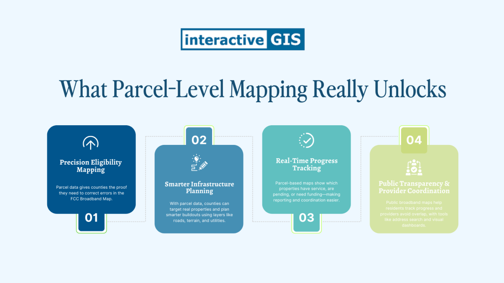
1. Precision Eligibility Mapping
Counties can use parcel data to challenge errors in the FCC Broadband Map—the official foundation for BEAD funding. If the map says a property is covered, but you know it isn’t, parcel-level data gives you the evidence to correct it.
2. Smarter Infrastructure Planning
Instead of drawing service zones over general areas, counties can identify actual homes and businesses to connect. InteractiveGIS integrates parcel data with roads, topography, and utility layers to help plan routes and prioritize investments.
3. Real-Time Progress Tracking
Parcel-based maps let you monitor exactly which properties now have service, which are in progress, and which still need funding. This makes grant reporting and provider coordination far simpler.
4. Public Transparency & Provider Coordination
A public-facing broadband map can answer common resident questions—”When will we get internet?”—and help prevent overlap between providers. InteractiveGIS platforms support search-by-address, custom dashboards, and visual status updates.
Why Parcel-Level GIS Is the Future of Broadband Planning
Broadband isn’t just a convenience, it’s infrastructure. It supports students, seniors, small businesses, and emergency responders. It’s how counties thrive in the modern world. But broadband planning only works when maps are accurate.
Parcel-level GIS makes broadband mapping local, specific, and real. It helps communities:
- Build smarter
- Spend efficiently
- Serve everyone
Because connecting the unconnected doesn’t start with fiber, it starts with a map that makes sense.
Want to see your local government’s broadband picture more clearly? Contact the InteractiveGIS team to chat!